
Best Hikes on New Zealand’s North Island
New Zealand, Oceania / February 20, 2026 / 6 comments
Hiking in New Zealand’s North Island offers a captivating journey through a diverse tapestry of landscapes, showcasing the island’s natural beauty and cultural richness.
This post has some of the best hikes on the island from an hour-long one with views of Auckland to an overnight one in Cape Brett!
Throughout your journey, you will also encounter the rich cultural heritage of the Māori people. Engage in the stories and legends that accompany these landscapes, and discover the deep spiritual connection that the Māori have with the land.
Hiking in the North Island of New Zealand is an immersive experience that unveils the island’s natural wonders, from ancient forests to volcanic landscapes and stunning coastlines. It is an opportunity to forge a profound connection with both the environment and the vibrant culture that defines this captivating region.
This post contains affiliate links. This means if you purchase something from a link, I may make a small commission, at no cost to you. This helps me keep the site running and free.
If you like this post, be sure to sign up for my e-mail list for travel inspiration & tips, or connect with me on Facebook, Instagram, Twitter, BlueSky, Threads, or Pinterest. I also have a Facebook group where you can ask me anything travel related – and I share travel deals!
Cape Brett Walkway
The Cape Brett Walkway is one of the best hikes in New Zealand’s North Island. The in-and-out track is 16.3km (10.1 mi) and takes 7-8 hours each way. It is typically completed as an overnight hike with a stay in the picturesque Cape Brett Hut.
However, if you’re short on time or just want to skip a few kilometers, there are also options to take a scenic water taxi either there or back.
The track meanders through beautiful native bush and out to the photogenic lighthouse at the end of Rawhiti Peninsula, with sweeping views out over the Bay of Islands the whole way. Be sure to check out the famous Hole in the Rock and keep an eye out for dolphins that like to play in the sea below the hut!
The track can be a little more demanding than expected due to its undulating nature. It’s also important to carry enough drinking water for the entire trip as water storage (only available at the hut) can sometimes be contaminated by salt spray. Toilets, cooking stoves & mattresses can all be found at the hut, but note that camping in tents is not permitted on the peninsula. Track permits can be purchased online and the hut should be booked well in advance, especially during the busy summer season.
Car parking is available in Rawhiti (for a fee), and water taxis pick-ups and drop-offs can be arranged from Rawhiti, Paihia, or Russell.

Kaiate Scenic Reserve & Te Rerekawau Falls
The Kaiate Scenic Reserve and Te Rerekawau Falls is a local gem in the Bay of Plenty featuring a short hiking trail leading to a series of spectacular cascading waterfalls.
This 0.8-kilometer (0.5-mile) moderately challenging track takes less than half an hour to complete. The well-formed trail loops through native forest, across bridges and up a series of stairs offering various vantage points to view the falls. You’ll see how the Kaiate Stream drops over bluffs creating a series of cascades that make up the Te Rerekawau Falls (also known as the Kaiate Falls or The Shag Falls).
It’s a great hike that isn’t a big commitment on time but offers a decent challenge along a variety of terrain. The main track leads to the Lookout Seat offering views from a higher vantage point. On a clear day, you can see all the way to Mount Maunganui in the distance. Then, the trail continues to the base of the upper and lower falls with several pools to swim in (if safe to do so) along the way. It’s a fun track the whole family can enjoy.
There is a medium-sized parking lot at the start of the track but no toilet or water refill stations. The track is open all year round although some sections of the track may be closed for repairs. The falls come to life after rainfall, which can also make the track muddy and slippery so do take extra care. Also, keep an eye out for safety signage to ensure the pools are safe for swimming before jumping in.

Kauaeranga Kauri Trail
The Kauaeranga Kauri Trail, better known as the Pinnacles Walk, is a popular day or overnight hike on the Coromandel Peninsula, and for good reason. Combining fascinating gold mining history with stunning views over the surrounding forests, it’s a rewarding way of getting back to nature without needing lots of time or special equipment to do it.
You’ll want to have a degree of fitness and a decent pair of shoes to climb the rocky trail as it rises to nearly 800m/2600ft above sea level, mind you: my calves certainly had something to say after four hours of climbing up to the summit!
The hut near the top sleeps up to 80 people, which is helpful for your chances of getting a bed for the night, and less helpful for your chances of avoiding snorers while you’re there.
You’ll pay $20/night for a bunk bed and need to book in advance: if you’re fit and start reasonably early, you can also choose to do it as a roughly 7-8 hour day hike instead and avoid bookings, fees, and snorers entirely.
Either way, it’s a total of 12km/7.5 miles return to Pinnacles Hut, plus 2km/1.2 miles to the summit. If the weather is good, I highly recommend climbing to the summit: the views easily make the extra climbing worthwhile!
There’s plenty of parking at the trailhead at the end of Kauaeranga Valley Road, along with toilets if you need them. There are also toilets at the hut, along with showers, water, and even a BBQ for those who are staying the night.

Mount Eden
One of the best small hikes in New Zealand is right at the doorstep of the country’s biggest city. Mt Eden in Auckland, also called Maungawhau, is a volcanic peak in the North Island of New Zealand. The peak is 196 meters above sea level, and it’s a short and easy walk up. In Māori culture, the summit of Maungawhau is sacred.
Walking up to the volcano is totally safe. The last eruption was 28,000 years ago, and the volcano is not active any more. It’s a very short hike, the return walk from the base of Mt Eden takes less than one hour. You can get to the starting point of the walk in a short time by bus, by taxi or by car from Auckland city centre. There’s a car park available and there are also public toilets.
The whole hill is a recreation area and there are multiple paths leading up to the summit. The main path starts at the main entrance on Puhi Huia Road. It’s just over 2 kilometres or 1.2 miles return, so a very short hike. Walking up the green hill Maungawhau in New Zealand you almost feel like a Hobbit. After all, The Lord of the Rings and The Hobbit were filmed not far from Auckland.
On top of the crater, there’s a wooden boardwalk on which you can circle the volcano without disturbing the Māori sacred ground. The volcano’s peak is the highest peak in the Auckland area, and there you’ll have the best views of the city of Auckland. So, even if you’re in Auckland for just one day it’s worth going up to Mount Eden.

Orongorongos Hike
Nestled within the breathtaking landscapes of New Zealand, the Orongorongo Track offers adventurers a truly remarkable hiking experience. The hike is a 6.3 mile (10.1 km) out and back trail featuring breathtaking views.
As you set foot on the Orongorongo Track, the air fills with an invigorating mix of earthy scents and bird songs. The trail unfolds through lush native forests, where sunlight filters through the canopy, creating a dappled tapestry on the forest floor. The symphony of nature echoes as the calls of tui and bellbirds serenade you along the way.
Traversing gentle slopes and babbling streams, the path gradually ascends, revealing panoramic vistas that leave you awe-inspired. With each step, the sweeping views of the Orongorongo Valley and its winding river below beckon you to immerse yourself in its grandeur.
Further along, you encounter the endemic flora and fauna that make New Zealand so unique. Towering rimu trees, ancient giants of the forest, stand tall, while ferns and mosses carpet the forest floor, adding an ethereal touch to the surroundings. If you’re fortunate, you might even catch a glimpse of a native kiwi bird, an elusive creature that epitomizes the spirit of this pristine wilderness.
The trail culminates in an idyllic picnic spot by the river, inviting you to rest and absorb the tranquility of your surroundings. Dip your toes in the crystal-clear water and savor a well-deserved lunch, knowing that this adventure has left an indelible mark on your soul.
The Orongorongo Track, with its abundance of natural beauty and diverse ecosystems, offers hikers an unforgettable experience. Whether you’re an avid adventurer or a nature lover seeking solace, this trail in New Zealand is a testament to the wonders of the natural world and an opportunity to forge an unbreakable connection with the wilderness.

Pouakai Circuit, Mount Taranaki
Tucked away in Taranaki, one of the lesser-visited parts of the North Island, is the verdant Egmont National Park, dominated by the soaring Mount Taranaki stratovolcano. To see it up close—but not the summit, it’s a sacred Maori site—embark on the two-or-three day Pouakai Circuit (15.5 mile/25 kilometre), one of the best hikes on New Zealand’s North Island.
Combining marshes, bush country, and plenty of birdlife, this circular tramp is remote and serene, though the highlights are undoubtedly the tarns (mountain lakes). On a wind-free day, these little pools promise a near-perfect reflection of the stratovolcano, with an overnight stay in one of the unstaffed cabins with hut-style toilets (pre-bookable from DOC for around $15) the best way to secure a still morning photo.
If you don’t have two days, the Mangorei Track—a 6 mile/10 kilometre day-trip version of the hike—also offers the chance to visit the tarns. Like the Pouakai Circuit, this trail starts from the car park on Mangorei Road, and the up-and-down route will take around 6 hours, although the first half is stair-heavy and less inspiring. Still, it’s only a 20-minute drive from the regional capital, making it one of the best things to do in New Plymouth—just be aware that winter snow often closes both trails, making the route most appealing from late spring until early autumn.

Mount Wellington
The Mount Wellington Hike near Auckland, New Zealand, offers adventurers a captivating journey through diverse landscapes and breathtaking views. It’s an easy 1.2 mile (a little under 2 km) that can be done in less than an hour!
As you begin your ascent on the Mount Wellington Hike, the bustling city of Auckland gradually fades away, replaced by a serene wilderness. The trail winds through verdant forests, where native trees and ferns create a lush canopy overhead. The air is filled with a refreshing blend of earthy scents and the distant melody of native birds.
As you gain elevation, the path opens up, revealing sweeping vistas of the Auckland region. The city’s iconic skyline stands in contrast to the surrounding natural beauty, creating a juxtaposition that is both striking and captivating. Take a moment to soak in the panoramic views of the sparkling Hauraki Gulf, dotted with islands that seem to float on the horizon.
The rugged terrain of Mount Wellington presents an invigorating challenge, with rocky outcrops and steep inclines demanding both physical and mental resilience. Alltrails rate the hike as moderate with a 300-foot elevation gain.
Upon reaching the top, a breathtaking panorama unfolds before you. The sprawling expanse of Auckland stretches as far as the eye can see, while the distant Waitakere Ranges and the majestic Waitematā Harbour provide a stunning backdrop. The sense of accomplishment is overwhelming as you realize the magnitude of the journey you have conquered.
The Mount Wellington Hike near Auckland is a testament to the natural wonders that New Zealand has to offer. Whether you’re an experienced hiker or a nature enthusiast seeking a memorable adventure, this trail promises an extraordinary experience that will leave an indelible impression on your heart and mind.

Red Rocks Coastal Walk
A unique urban hike you can do on the North Island is the Red Rocks Coastal Walk, which is just outside of the capital city of Wellington. This hike takes you along the rugged south coast of the North Island to Sinclair Head, which is home to a colony of New Zealand fur seals during the winter months (May-October).
You can drive or take a public bus to the Te Kopahou Reserve Visitor Centre in the suburb of Owhiro Bay (parking and toilets are both available at the visitor center). If you’re campervanning around New Zealand you can park here too. The trail starts here, and is a 7.4 kilometer (4.6 miles) out-and-back trail that ends at Devil’s Gate at Sinclair Head.
The trail is a mixed-use one; you can hike, bike, or even ride an ATV on it. (If you want to go at a quieter time, the track is closed to all vehicles on Sundays from 9 a.m.-6 p.m.)
Along the hike, you’ll pass a quarry, see the red rocks the trail is named after, and get magnificent views across the Cook Strait (you can see the tips of the Kaikoura Ranges on the South Island on a really clear day!). And if you’re hiking during the winter months, you are bound to see fur seals out at Sinclair Head – just be sure to give them a wide berth, as they are wild animals.
The Red Rocks Coastal Walk is a fairly easy one (the trail is flat and easy to follow), but pays off big in terms of scenery and wildlife. It’s one of the best things to do in Wellington once you’ve crossed off all the sites in the city center.

Tongariro Alpine Crossing
The Tongariro Alpine Crossing track is considered to be one of the best hikes in New Zealand. Its volcanic landscapes and breathtaking views make it one of the most popular ones in the North Island. Its popularity could partially be attributed to the fact that Mount Ngauruhoe, which stands on one side of the trail is featured in Peter Jackson’s Lord of the Rings as Mount Doom.
The 19.4 km (12 miles) trail is a point-to-point hike. This means that transport needs to be arranged on either side. Most people usually choose to begin the hike from Mangatepopo road and finish at Ketetahi road because there is less climbing that way. That does not mean that it is easy, though, as due to its terrain it takes between 9 and 11 hours to finish. A simple way to arrange transport is to find a campsite or hotel nearby that offers shuttle service. The trail is very exposed, and the weather can change rapidly.
There are toilets along the way, but it is advised to bring toilet paper.
What makes this hike great is the number of different dramatic landscapes along the way. Starting from Mangatepopo road, the path begins with a steady incline to Soda Springs at the hour – hour and a half mark. Next comes a very steep section called the Devil’s staircase that ends at south crater which falls between mt Ngauruhoe and mt Tongariro. At the end of south crater is the last steep section of the hike all the way up to Red Crater which is the highest point of the trail and the views from there are breathtaking. The next part of the trail is a steep descent on loose rocks which makes it a bit dangerous. But the view towards Emerald Lakes and Blue Lake in the distance is one of the most impressive ones along the hike. Blue Lake is sacred and it’s disrespectful to touch it or eat around it. From there all the way down to Ketetahi road, the trail is only downhill and the volcanic terrain is replaced by green hills and views of lakes Rotoaira and Taupo.

Whakarewarewa-Redwoods Forest
The Whakarewarewa-Redwoods Forest, near Rotorua on New Zealand’s North Island, provides a number of hiking opportunities under towering California Redwoods, first planted in 1901. Hikers can explore much of the 55 hectares of forest, which is a productive plantation open for recreational users.
The shorter Redwood Memorial Grove track is only 2 kilometres or 1.2 miles. This easy and quick route (about 30 minutes) also has a boardwalk across a thermal pond.
The longer Tokorangi Pa track is 11.5 kilometres or 7 miles and takes an average of 3 hours and 30 minutes to complete. The elevation on this path rises 500 metres above sea level and has great views of Mount Ngongotaha, Rotorua, and the surrounding area. The Tokorangi Pa route also passes the former site of a Maori pā (village) and includes a variety of other trees, such as Douglas Fir and Eucalyptus.
For these and other marked routes, it’s important to follow the directional signs; many paths are shared between hikers, horses, and bikers.
A highlight of the Whakarewarewa-Redwoods Forest is the sweet as toilets! Functional and beautiful, they were designed to work with the natural landscape and reflect the area’s Maori heritage.
Dogs are required to be on-leash. The Visitor Centre and i-Site has snacks and drinks available. It is open every day (except Christmas) from 9.30 am to 10.30 pm in summer or 9.30 pm in winter.
To get to Whakarewarewa-Redwoods Forest by bus, take route three and get off at Titokorangi Drive (Long Mile Road). For those driving, there are three gates that are open from 5.30am until late. The park is always open for entry on foot or bike.

Save “Best Hikes on New Zealand’s North Island” for Later


About the Author
Read More About New Zealand


6 responses to “Best Hikes on New Zealand’s North Island”

NZ has some awesome hikes. I’d love to go back one day and do the The Tongariro Alpine Crossing track. We drove through the area and it’s absolutely stunning.

Hi ~
What a great list! Another fantastic hike is the Pinnacles on the Coromandel peninsula. Great to time for a sunrise view if you can. There is a hut at the top so you can stay to watch it 😀
~ Christine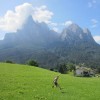
Squeeee! This is my kind of post! Each of these look fantastic (and I have only done one of them- Tongariro crossing!) We reeeally need to go back and explore more of Kiwiland! Top of my list is Pouakai Circuit, Mount Taranaki. Incredible!

What a great hiking list. Thank you for sharing!

Wow NZ looks so beautiful! I love hiking, need to add a trip to NZ to the bucket list! Thanks for sharing

Love the detailed explanation and insider tips! Hope I will make it to New Zealand one day so I can try some of these hikes
Have You Seen These Yet?


Hey there! I’m Pamela. Just a woman who has fallen in love with getting lost around the world. I’ve traveled to 42 countries across 7 continents.
My mission? To inspire you to ‘let the bucket list flow’ and see what the world has to offer.
My promise: All of my photos are not edited. What you see is what you get.
Join a small-group safari to Kenya & Uganda!
- Go trekking and get close to gorillas and chimpanzees
- See the big 5 Safari Animals
- See The Great Migration
- Sunrise hot air balloon ride and champagne breakfast included
- Maximum of 12 guests
Capital Cities book

- Discover the world through this 258 page book covering 118 cities
- 3 photos by me!
- Perfect as a gift or for your coffee table
Travel Shop
- Accommodation Comparison Excel
- Printable Bucket Lists
- Travel Planning Resources
- & More!
Leave a Reply